Cleveland Metroparks Bedford Single Track Mountain Bike Trail
About This Trail
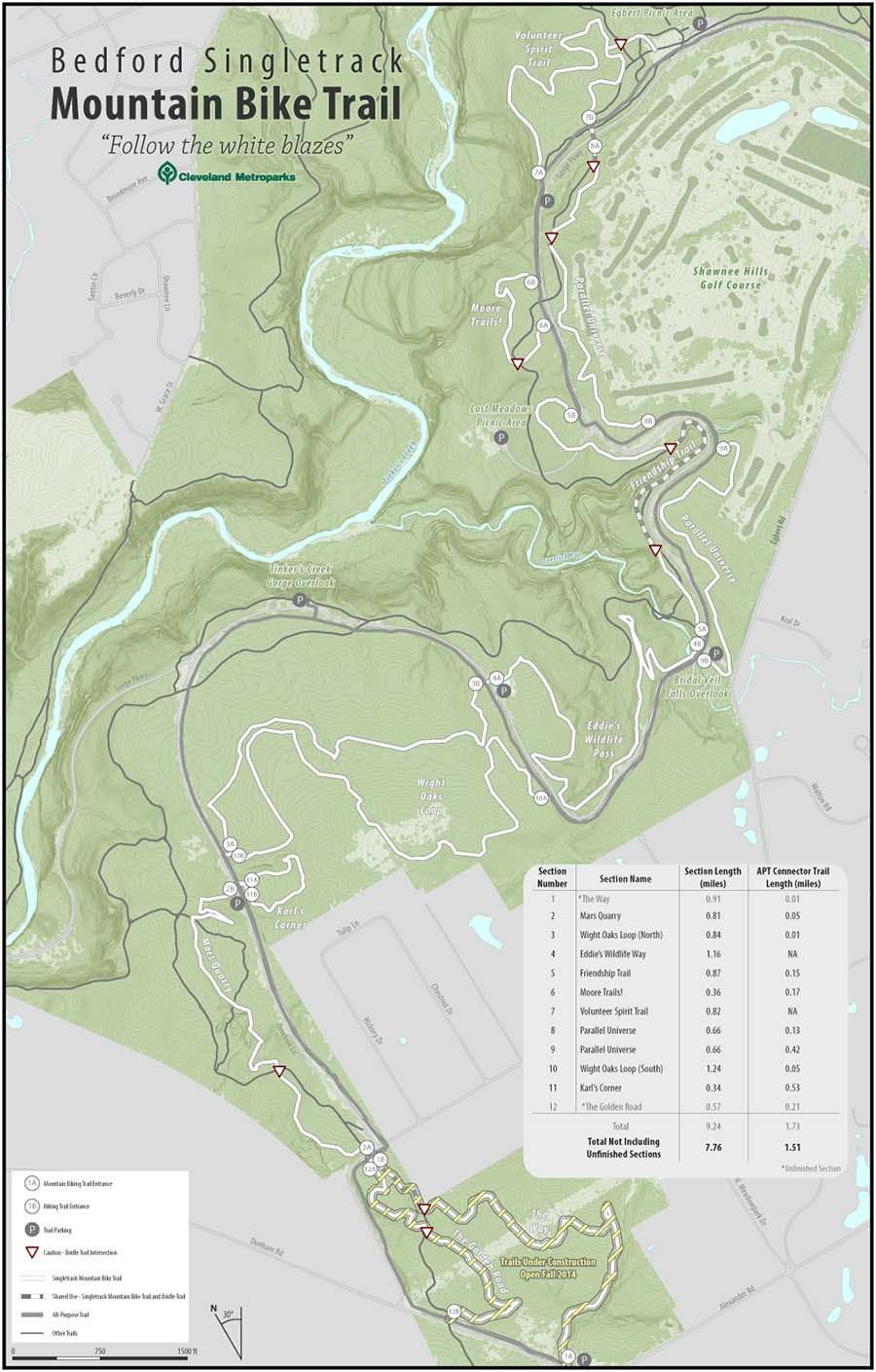
 With great anticipation and fan fare, the Cleveland Metroparks unveiled their third mountain biking trail system to the public on June 7, 2014. Located in the Bedford Reservation in Bedford, Ohio, the Bedford Singletrack Mountain Bike Trail uses an innovative design and layout.
Very beginner-friendly, the trail consists of several short loops that start and end on the park's paved All-Purpose Trail (APT). So, you can try out the mountain bike trail in bite-size pieces, connecting as many or few sections of singletrack as you want, always with a bail-out point nearby on the APT.
If you ride the entire system of singletrack, plus the connecting All-Purpose Trail, you will ride a little over 12 miles.
The trail is open to mountain bikers and hikers. To minimize conflicts, the layout and signage is designed so that mountain bikers travel in one direction, while hikers travel in the opposite direction.
The trail also crosses and overlaps the park's bridle trails in a few places, so observe proper trail etiquette in these places; stop and yield to horses.
Go to @CMPmtb on Twitter to check the latest trail open/closed status.
Location and Directions
The primary mountain biking trailhead is located at the Egbert Picnic Shelter, located at the northern end of the Gorge Parkway. Ample parking is available, as well as restrooms and a water fountain.
There is also a do-it-yourself bike fix-it station located here, next to the All-Purpose Trail, near the far end of the grassy area where the Egbert Picnic Shelter is located. This station has a bicycle work stand, air pump, plus a selection of common bike repair tools (tire levers, screwdrivers, hex wrenches, open-end wrenches).
There are secondary trailheads located at the intersections of Overlook Lane and Egbert Road, or at Alexander and Dunham Roads. There is limited parking at both places, but no restrooms or water fountains.
Directions to Egbert Picnic Shelter:
From Cleveland and other points north and west:
1. Take I-480 East or I-271 South.
2. Take Exit 23 for Forbes Rd/Broadway Ave.
3. At the first traffic light, turn RIGHT onto Forbes Rd.
4. At the next immediate traffic light, turn RIGHT onto Broadway Ave.
5. Make a gentle LEFT onto Union St.
6. Turn LEFT onto Egbert Rd.
7. Turn RIGHT onto Gorge Pkwy.
8. Parking lot is just ahead on the right.
From Akron and other points south and east:
1. Take I-480 West or I-271 North.
2. Take Exit 23 for Forbes Rd/Broadway Ave.
3. Turn LEFT onto Broadway Ave.
4. Continue at step 5 above.
Trail Map
Click here for an interactive map of the Bedford Singletrack.
Click here for Trail Conditions and Closures.