Austin Badger Mountain Bike Trail
About This Trail
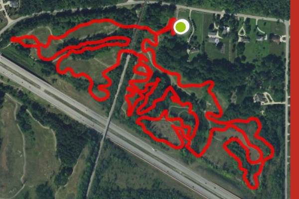
Parking and restrooms are provided at the park entrance. The "main" trailhead can be found by following the paved cart path up the first hill after crossing the bridge - it's on the left. The trail crosses the cart path several times and is marked with striping or paint. The normal flow of the trail is clockwise with occasional transitions on the cart path.
Austin Badger officially opened the mountain bike trails in October of 2016. The site of a former 18 hole golf course, Austin Badger was repurposed into machine cut and shaped trails complete with berms, jumps, short technical climbs, and descents. The cart path is also used for biking and hiking if you're not up to dirt just yet. Use caution at all cart path crossings.
The 252-acre property was purchased by Montville Township in 2015 through the Ohio Public Works Commission to be utilized as a nature preserve. The park offers other activities such as running, biking and walking, nature education, and picnicking in designated areas. There are also outdoor fitness stations donated by the Cleveland Clinic and a 3.6-miles of purpose built mountain bike trail donated by the Cleveland Area Mountain Bike Association. An additional 12 miles have been proposed and we hope this happens sooner than later.
Once the Blue Heron Golf Course, the park has nineteen bridges and 7.5 miles of concrete walking trails throughout the property. While it may be years before the entire park will be open, the area along River Styx Road was opened in 2016. Austin Badger Park was named in memory of one of Montville Township’s first Trustees and settlers.
Check trail conditions at:https://www.facebook.com/badgerMTBtrail/
Get a virtual tour: https://www.mtbproject.com/trail/7020491/austin-badger-mtb-trail
Location and Directions
Austin Badger Mountain Bike Trail is located in Montville Township, Medina Ohio.
The physical address is:
5741 River Sytx Road
Medina, Ohio 44256
- Take Interstate 71 to Exit 218 for State Route 18.
- Go WEST on State Route 18.
- Turn LEFT onto River Styx Road.
- Go about 1.3 miles and the parking lot is on the left.
Trail Map
